01 יוני, 2013

ארצו של אלכסנדר מוקדון- כללי The country of Alexander III of Macedon- over view

ארצו של אלכסנדר מוקדון The country of Alexander III of Macedon

כתבה זו פותחת סדרת כתבות על טיול במקדוניה העתיקה  Old Macedonia, ארצם של אלכסנדר מוקדון Alexander III of Macedon ואביו פיליפוס השני Philip II of Macedon, שהשתרעה על שטחים הנמצאים כיום בעיקר בתחומן של שתי מדינות, בחלק הדרומי של "הרפובליקה של מקדוניה" ובחבל מקדוניה שבצפון יוון, ושתי מדינות אלו רבות ביניהן על השימוש בשם, בסמלים ובדמות של אלכסנדר מוקדון.
כך נראה של שטחה של מוקדון העתיקה בתקופת מותו של פיליפוס 336 לפנה"ס ועלייתו לשלטון של אלכסנדר מוקדון-

וכאן תוכלו לראות את מפת מקדוניה העתיקה לפני עלייתו של פיליפוס השני לשלטון- מפה
לפני שניכנס למחלוקות שהצבעתי עליה קודם בין המדינות יוון ומקדוניה, כדאי שנכיר מעט את מקדוניה העתיקה.
מקדוניה העתיקה, הייתה מדינה ששכנה בחבל הבלקן של ימינו, בין טרקיה מצפון, בין תסליה וממלכת המלוסים מדרום, והייתה נדבך מרכזי בהתפתחות ממלכת יוון בתקופה ההלניסטית. קיומה החל מהמאה ה- 9 לפנה"ס, השפעתה באזור החלה בימי פיליפוס השני שכבש את יוון כולה, והמדינה או ליתר דיוק הממלכה הגיעה לשיאה בתקופתו של אלכסנדר מוקדון.
עוד על מוקדון העתיקה מיתן ללמוד בלינק הבא- מוקדון העתיקה.

הערים המרכזיות שהיו בה וידועות לנו כיום הן :-
העיר פלה pela שבה נולד אלכסנדר מוקדון, שבתקופתו שכנה לחופי הים האגאי, בדיוק כמו סלוניקי כיום, העיר ורג'ינה vergina שבה נקבר פיליפוס השני, אביו של אלכסנדר מוקדון, ומספר אנשים ממשפחת המלוכה. גם היא ישבה בזמנו לחופי הים האגאי, העיר דיון dion שישבה אף היא לחופי הים האגאי, כל אלו בחבל מקדוניה שביוון, והעיר הרקליה ליד ביטולה ברפובליקת מקדוניה.

מפה זו מראה כיצד התרחקו ערים אלו מקו החוף עקב שינויים טופוגרפיים שנגרמו כתוצאה מרעשי אדמה או סחף-
From מקדוניה כללי
התמונה הראשונה למעלה משמאל מצביעה על המצב הראשוני, למעלה מימין - תחילת סתימת המפרץ, למטה משמאל - מצב שבו יש רק נהר המוביל למפרץ,  למטה מימין - המצב כפי שקיים כיום.

מיד אם עלייתו של אלכסנדר מוקדון Alexander III of Macedon או בשמו האחר אלכסנדר הגדול Alexander the Great לשלטון, הוא החל במסע כיבושים, שבסיומה ממלכתו הייתה גדולה מכל ממלכה אחרת בעולם, למעט הממלכה הבריטית. על המנהיג והכיבושים תוכלו לקרוא בלינק הבא- אלכסנדר מוקדון.

מפה של מסעות הכיבוש שלו-
 מקור כאו

 מפה נוספת שצולמה במוזיאון שבעיר פלה-

From מקדוניה כללי
כאמור הוויכוח והמחלוקת בין רפובליקת מקדוניה לבין חבל מקדוניה ביוון היא בתחומים רבים.

סמלים ודגלים
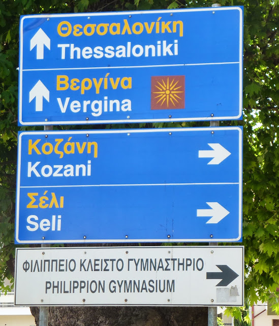
"שמש ורגינה" או בשמותיה האחרים "כוכב ורגינה" או "כוכב ארגיד" היא למעשה כוכב בעל 16 קרניים או 12 קרניים שנתגלה על ארונות הקבורה של מלכי מוקדון העתיקה בורגינה.
סמל זה מופיע היום בשילוט המוביל לעיר ורגינה, כפי שמופיע בתמונה.

From מקדוניה כללי

סמל זה, בשינויים קלים, שימש ומשמש אף כיום את שתי המדינות המשייכות את עצמן לשושלת ולתרבות מקדוניה העתיקה.
חבל מקדוניה ביוון משתמש בסמל זה ע"ג הדגלים שלו מאז 1993, וכך נראה הדגל-


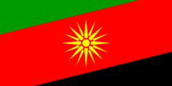
וגם רפובליקת מקדוניה אימצה לעצמה את הסמל הנ"ל על דגלה בין השנים 1991-1995, אפילו לפני חבל מקדוניה ביוון, וכך הוא נראה -


בשנת 1993 העביר הפרלמנט היווני הצעת חוק שהפכה את שמש ורגינה לסמל לאומי ביוון, וב-1995 הגישה תביעה לרישום הסמל כסימן מסחרי תחת פסקה 6 של אמנת פריז, יוזמה שרפובליקת מקדוניה התנגדה לה.
אך בעקבות לחצים בין לאומיים ותביעה של יוון על גניבת סימן מסחרי, הוחלף הסמל הנ"ל בדגלה של רפובליקת מקדוניה בשמש של 8 קרניים, סמל שנתגלה בחפירה ארכאולוגית בעיר טרנובק ברפובליקת מקדוניה, והיה בשימוש כסמל של קהילת הארומנים וכך נראה דגל רפובליקת מקדוניה כיום-  


למרות הפשרה שהושגה, מחוז מקדונקה קמניקה שברפובליקת מקדוניה השתמש ועדיין משתמש בסמל 16 הקרניים על דגלו, וכך הוא נראה -


שדות תעופה

שדה התעופה של רפובליקת מקדוניה נמצא בעיר הבירה סקופיה ונקרא "שדה התעופה אלכסנדר הגדול Alexander the Great" שסימונו (skp), ואילו שדה התעופה שבסלוניקי שביוון נקרא " שדה התעופה מקדוניה Makedonia " שסימונו (skg) וגם שדה התעופה ליד העיר קוזאני kozani שביוון, הנמצאת מדרום מערב לעיר ורגינה, נקרא  "שדה התעופה פיליפוס Philippos " שסימונו (kzi).

שילוט בין מדינות וכינוי המדינות

בנסיעה מכיוון רפובליקת מקדוניה לכיוון יוון השילוט מצביע על Greece, אולם על השילוט מיוון לכיוון רפובליקת מקדוניה לא תמצאו את המילה Macedonia או הרפובליקה של מקדוניה או כל הקשר דומה, וכל מה שתמצאו הוא שילוט ל- סקופיה Skopia.
גם אם תגידו ביוון שבאתם או אתם נוסעים למקדוניה או רפובליקת מקדוניה, אזי במקרה הטוב לא יבינו להיכן התכוונתם או במקרה הגרוע יתעלמו או יתקנו אתכם כאשר כבר יבינו ויגידו לכם שבאתם מסקופיה.

פסלים

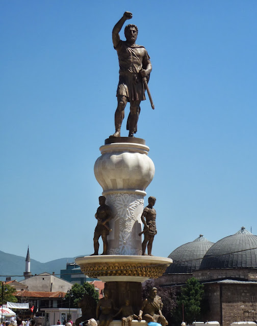
בשתי המדינות, בכל מקום היסטורי או בערים ובכפרים תמצאו פסלים רבים של אלכסנדר מוקדון או אביו פיליפוס השני, וכאמור כל מדינה מנכסת לעצמה את הגיבורים הללו כגיבורי המדינה שלהם.

להלן תמונות שצולמו ברפובליקת מקדוניה -

From מקדוניה כללי
 בביטולה bitola

From מקדוניה כללי
 בכיכר המרכזית בעיר העתיקה של סקופיה

ולהלן תמונה שצולמה בחבל מקדוניה שביוון -

From מקדוניה כללי
 בסלוניקי thessaloniki הכוללת את שמש וירגינה


מטבעות ועוד

משנת 1990 ועד החלפת הדרכמה היוונית באירו בשנת 2001 הוטבעה שמש ורגינה בחזית מטבעות 100 דרכמה, כמו כן הופיעה שמש ורגינה על טלאי הידיים של כוחות המשטרה בבירה אתונה.
גם תחנת הטלוויזיה מקדונה TV שבסלוניקי (בירת חבל מקדוניה ביוון והעיר הגדולה ביותר בה) החליפה את סמלה לשמש ורגינה מאומיקרון,  גם בנק מקדוניה אימץ את הסמל לחיקו וכך גם מספר יחידות צבאיות.

כפי שנראה לי הוויכוח רחוק מסיום והוא יימשך עוד שנים רבות.

לאחר המידע הכללי על ממלכת מוקדון העתיקה, בהשלכה לחלוקתה היום בין המדינות, כל מה שנותר הוא לתת לכם קצת מידע כללי על רפובליקת מקדוניה שלגביה אין מידע מספיק או מידע עדכני.  בכתבה זו לא יימסר מידע על יוון או על חבל מקדוניה שביוון, כי על מדינה זו יש מידע רב ומסודר, והמידע היחידי שיינתן הוא המידע בכתבות ההמשך לגבי כל אתר ואתר.

רפובליקת מקדוניה macedonia -במקדונית  Република Македонија

היא הרפובליקה היוגוסלבית לשעבר המוקפת מכל עבר במדינות סרביה, בולגריה, אלבניה ויוון. המדינה גובלת ביוון בדרום, באלבניה במערב, בסרביה בצפון ובבולגריה במזרח.

הרפובליקה קיבלה עצמאות ב-1991 בעקבות פירוק הפדרציה של יוגוסלביה. מקדוניה היא כיום דמוקרטיה פרלמנטרית.
מקדוניה הייתה ממוקמת ועדיין ממוקמת על דרך סחר ראשית וחשובה מיוון לכיוון פנים יבשת אירופה.
המקדונים הם צאצאיהם של הסלאבים אשר פלשו לכאן במאה השישית ויצרו את האימפריה הבולגרית המפוארת.
המקדונים הצליחו להגן על חבל הארץ שלהם, לשמר את עצמאותם התרבותית ולשמור את נופיה הייחודיים ואוצרות חבלי ארצם. על ההיסטוריה שלהם תוכלו ללמוד בלינק הבא-
http://www.eco-tarbut.co.il/content.asp?cat=39 


נתונים גיאוגרפים
המדינה שוכנת בדרום-מזרח אירופה, ללא מוצא לים. שטחה של מקדוניה 25,333 קמ"ר מחורץ, והיא גדולה בקרוב לרבע משטחה של מדינת ישראל. כך שטיול במדינה זו יחשוף בפניכם נופים שונים ומגוונים: נהרות ואגמים, הרים ועמקים.
זוהי ארץ האגמים הגדולים, שהם מן העתיקים ביותר בעולם הגיאולוגי. המקדונים מכנים את ארצם "ארץ האגמים וההרים"
"Macedonia is a country of lakes and mountains".

מקדוניה היא ארץ של רמות, וגובה פני השטח במרבית חלקיה הוא יותר מ-600 מטר מעל פני הים. הפסגה הגבוהה ביותר במקדוניה, הר טיטו (2,748 מטר מעל פני הים), נמצאת בצפון-מערב המדינה, על הגבול עם חבל קוסובו שבתחומי סרביה. נהר וַרְדַר, הזורם מצפון לדרום-מזרח ונשפך למפרץ תרמייקוס שבים האגאי, חוצה אותה במרכזה. בדרום-מערב מקדוניה, במפגש הגבולות עם אלבניה ויוון, נמצאות שתי הימות הגדולות אוֹכריד ופְּרֶסְפָּה.

ההרים משתייכים לשני רכסים שונים: דינארסקה ורודופסקה. רכס דינארסקה הוא העתיק יותר ורכס רודופסקה הוא הצעיר יותר מבניהם ופני השטח שלו הם הרריים ומחוספסים, וגובה ההרים נע בין 1800-2800 מטר.
From מקדוניה כללי
 בעיר ביטולה שמדינת מקדוניה

שמורות הטבע
שמורות הטבע העיקריות במקדוניה הן:- 
גליציה (Galicica (Galicica mountain, מרובו (Mavrovo (Bistra, Korab, Desat mountains ופליסטר (Pelister (Baba mountain .


אקלים
מזג האוויר במקדוניה, לרוב מסביר פנים לתייר. הקיץ חם (מעט פחות מאשר בישראל) החורף קר (מעט יותר מאשר בישראל, עם שלגים ברמה ההררית) והעונות המוצלחות ביותר לטיול הינן כמובן האביב והסתיו. 

מבחינת אזורי אקלים - מקדוניה שוכנת בין קווי רוחב 40 ל 42 והאקלים במקדוניה משלב אקלים ים תיכוני עם האקלים של פנים יבשת אירופה. מכיוון שהמדינה שוכנת בדרומה של היבשת, היא כוללת בתוכה מספר רב של תת אזורי אקלים ובתוכם:
בדרומה של המדינה קיימים אקלים ים תיכוני הרלוונטי לאזור הים התיכון (מ -50 מטר עד 500 מטר מעל פני הים), ואקלים יבשתי מתון (באזורים עד 600 מטר), 
מעט יותר צפונה שורר אקלים יבשתי חמים (מ -600 עד 900 מטר מעל הים), שוב אם נעלה מעט צפונה (באזור קו רוחב 41) שורר אקלים יבשתי קר (מ 900 מטר ל 1100 מטר), 
אקלים יבשתי קר שורר גם באזור ההר (1100 - 1300 מטר) באזורי הרמה של מקדוניה ואזורי ההרים במקדוניה שוררים אקלים תת-אלפיני (1,650 ל 2,250 מטר) ואלפיני (מעל 2250 מטר מעל פני הים).
לפרטי מזג האוויר העדכני בערים השונות של מקדוניה, כולל פרוט מלא בעברית, בזמן אמת, לחץ כאן או בלינק הבא
 http://www.wunderground.com/global/MK.html 

אוכלוסייה
אוכלוסיית מקדוניה: כ-2.1 מליון נפש נכון לשנת 2002, ובירתה של מקדוניה היא סקופיה (Skopje) כ-440,000 איש והיא גם המרכז התרבותי, הכלכלי והחברתי של המדינה. דבר המגדיר אותה כאחת מן המדינות המרווחות באירופה בכל הקשור ליחס שבין השטח למספר התושבים. 
עיר חשובה לא פחות מבחינה תיירותית הינה אוכריד, שם מצויה העיר העתיקה והעיר העותמנית של אוכריד. הערים הנוספות החשובות במקדוניה הינן : Bitola, Kumanovo, Ohrid, Tetovo, Veles, Gostivar, Stip ו- Strumica.

From מקדוניה כללי
 בסקופיה שבמדינת מקדוניה

הרכב אתני: 66% מקדונים, 23% אלבנים, 4% טורקים, 4% צוענים, 2% סרבים. דת: 67% נוצרים אורתודוכסים, 30% מוסלמים. חלק גדול מהפוליטיקה נסוב סביב השאלה האלבנית. רבע עד שליש מאוכלוסיית מקדוניה הנמצאים בעיקר במערב, הם אלבנים שמזהים עצמם עם אלבניה. דבר זה הביא לכמעט מלחמת אזרחים ב- 2001, והוא הנושא העיקרי בפוליטיקה. מקדוניה הושפעה מאד מהמלחמה בקוסובו בפרט, ומלחמות הבלקן בכלל.

תרבות ודתות מקדוניה
במקדוניה קרוב ל-160 מנזרים פעילים, כמו בבולגריה, אבל בשטח שהוא חמישית בגודלו. בחלק מהמנזרים אפשר ללון ורובם ישמחו לקבל אורחים, וזאת בנוסף למאות כנסיות בכל כפר ועיר. מקדוניה היא ארץ טובה לטייל בה בעקבות הנצרות הסלאבית, מכיוון ששם תחילתה.

עוד על התרבות בלינק הבא- http://www.eco-tarbut.co.il/content.asp?cat=41

במסגרת התרבות המקדונית, בכל חתונה הם נוהגים להניף כל הזמן את הגדל המקדוני ואף לקשור לו בקצה אריג עם סמלים שלא הבנתי את פשרם.

From מקדוניה כללי


From מקדוניה כללי

מטבע
דינר מקדוני  MKD ערכו ל- 2013 הוא 1 ארו= 61 דינר.

חשמל
220 וולט

הפרשי שעות
מקדוניה מאחרת את שעון ישראל בשעה אחת.

תקשורת
קידומת חיוג בינלאומית :+389


משטרה: Police: 192
סיוע רפואי:Medical Emergency: 194
סיוע בדרכים:Road Assistance: 15555
מידע על דרכים:Road Info Center: 196
הכוונה: Infomartion desk / Directory Assistance: 188

אשרות ושגרירויות
ישראלים המבקרים במקדוניה אינם זקוקים לאשרה. למגיעים למקדוניה חייב שיהיה דרכון בתוקף, והשהייה הינה חופשית למשך 90 יום. בכניסה לגבולות המדינה, מוטבע הדרכון עם התאריך הנוכחי על מנת לוודא את תקופת ה 90 יום המותרת.
המידע המודגש בהמשך ושמסתובב באתרים שונים, מוטעה, ואף אחד מהדברים הללו לא נדרש להצגה, לפחות לא בשנת 2013, מקדוניה אינה דורשת מכל תייר הוכחה לביטוח בריאות תקף בשדה התעופה, בביקורת הגבולותאין צורך להירשם בתחנת המשטרה הקרובה תוך 24 שעות מהגיעכם. המדינה מודרנית ונוהגת ככל מדינה באירופה.

נציגות מקדוניה בישראל
כתובת: שוהם 5-7, קומה 9, רמת גן
טלפון: 073-7154900

לישראל שגריר לא תושב במקדוניה
טלפון: 02-5303817
טלפון נייד:  050-6203256

העונה המומלצת לביקור
העונה הטובה ביותר לבקר במקדוניה היא בין מאי לספטמבר. שיא עונת התיירות במדינה היא מאמצע יולי לאמצע אוגוסט, כאשר המקומיים יוצאים לחופשה השנתית שלהם, ואז גם רוב האתרים עמוסים בתיירות מקומית ובינלאומית.


כיצד להגיע למקדוניה
בדרך האוויר- האפשרויות הן מישראל לאירופה (טורקיה, בולגריה או יוון) ומשם לבירת מקדוניה סקופיה.
בדרך היבשה- מכל אחת מהמדינות הגובלות עמה: אלבניה, יוון, בולגריה קוסובו וסרביה, וישנן שלוש אפשרויות :-
ברכבת
מזגרב שבקרואטיה, מליובליאנה שבסלובניה, מקוסובו וסלוניקי שביוון, וכולם מגיעות לסקופיה.

באוטובוס
מהתחנה המרכזית בסופיה שבבולגריה יוצאים אוטובוסים ישירים בכל בוקר ובכל אחרי צהריים לסקופיה ולאגם אוכריד.
ניתן להגיע גם בתחבורה ציבורית גם מזגרב שבקרואטיה, מליובליאנה שבסלובניה, מסרביה, מקוסובו, גרמניה וטורקיה.

From מקדוניה כללי
 בכיכר המרכזית בסקופיה שבמדינת מקדוניה

ברכב מושכר
אפשר להגיע למקדוניה ברכב מושכר, אך רוב המדינות שרשומות בהמשך לא מאפשרות לרכביהם להיכנס למקדוניה, ואם כן מאפשרות יש להצטייד בניירת המתאימה מחברת הביטוח שתאפשר את המעבר.
לעומת זאת, השכרת רכב במקדוניה מאפשרת לכם לנוע לכל אחת מהמדינות הסובבת אותה, בלי בעיות, ורק צריך להודיע מראש כי אתם מעוניינים לעבור למדינות שכנות בכדי להסדיר לכם את הניירת המתאימה ולשלם 20 ארו לצורך כך. מומלץ להזמין רכב מראש כבר מהארץ ולעשות גם ביטוח מורחב כולל ביטול השתתפות עצמית.
הכניסה והיציאה ממקדוניה היא דרך כל אחד ממעברי הגבול עם המדינות הגובלות לפי הפירוט הבא:-
3 עם בולגריה לפי הפירוט הבא- Deve Bair near Kriva Palanka, Novo Selo near Strumica, and Delcevo.
3 עם סרביה לפי הפירוט הבא:- Tabanovce, Sopot and Pelince near Kumanovo.
2 עם קוסובו לפי הפירוט הבא:- Jazince near Tetovo; and Blace near Skopje.
3 עם יוון לפי הפירוט הבא:- Bogorodica near Gevgelija, Medzitlija near Bitola, and Star Dojran near Dojran.
4 עם אלבניה לפי הפירוט הבא:- Stenje near Resen, Sveti Naum near Ohrid, Kjafasan near Struga, and Blato near Debar

התניידות בתוך מקדוניה
אוטובוס
במקדוניה ישנה רשת אוטובוסים מפותחת. אוטובוסים רבים יוצאים מסקופיה אל רוב הערים המרכזיות והם נוחים ובטוחים. כדאי לקנות כרטיס בתחנת האוטובוס יום או יומיים לפני הנסיעה אם אתם נוסעים לאוכריד בשיא עונת התיירות.

 מונית
מוניות מהוות פתרון נוח להגעה למנזרים ואתרים מרוחקים אליהם האוטובוס לא מגיע. המוניות במקדוניה זולות מאוד ביחס לסטנדרט האירופאי וכדאי לנצל אותן.

רכבות במקדוניה
למקדוניה, מערכת מפותחת של תחבורה ציבורית (ירושת השלטון הקומוניסטי של יוגוסלביה). כל הקווים המקומיים מתופעלים ע"י חברת רכבת מרכזית אחת, "רכבות מקדוניה" (Makedonski Zheleznici). סך אורך קווי הרכבת במקדוניה הינם 900 ק"מ. מסקופיה יוצאות רכבות לכל מקדוניה ובכלל זה לצפון (לקומנובו - Kumanovo) למערב (טאטבו - Tetovo), למזרח (שטיפ - Shtip), למרכז מקדוניה (ואלס - Veles) לדרום-מזרח גאבג'ליצ'ה (Gevgelija) ולדרום-מערב (פרילאפ - Prilep) וביטולה (Bitola).
From מקדוניה כללי
 בסקופיה בירת רפובליקת מקדוניה

מסמכים, כבישים ודרישות תנועה לנהיגה ברכב מושכר
לישראלים הרוצים לנהוג במקדוניה, נדרש רק רישיון נהיגה ישראלי בר תוקף ולא חייב  רישיון נהיגה בינלאומי.
הכבישים הבינעירוניים מתוחזקים היטב, אבל כבישי המשנה משובשים, מאוכלסים לעיתים בעגלות רתומות לסוס או חמור ולא מוארים. בהרים - הדרכים מפותלות, צרות, לא מסומנות כראוי, חסרות גדרות בטיחות ומסוכנות. כל זה נכון כפל כפליים כשמזג האוויר מתחיל להיות חורפי (גשם, כביש רטוב, ערפל ורוחות). 
חובה לנהוג עם אורות דולקים בכל ימות השנה, בעיר ומחוץ לעיר, וכמובן חייבים לחגור חגורות בטיחות.
המהירות היא בהתאם לשילוט בדרכים, אך דרישות הבסיס הם:- באזור עירוני 60 קמ"ש, בכבישים בין עירוניים 80-100 קמ"ש, בדרך מהירה 120 קמ"ש.
נסיעה בכבישים המהירים מחייבת תשלום אגרה לאורך הכביש, לכן חשוב להכין כסף מקומי כבר ליום הראשון, כי מיד אחרי היציאה משדה התעופה עולים לכביש כזה בכדי להגיע לסקופיה או להמשיך לכל יעד אחר. אם אין לכם כסף מקומי אפשר לשלם גם ביורו, אך רק בשטרות ולא במטבעות ולקבל עודף בכסף מקומי, כאשר שער ההמרה לא ברור, אז תכינו לפחות כמה שטרות קטנים ביורו.

החגים במקדוניה

January 1 -   New Year
January 7 -   Christmas Eve
April -          Easter
May 1 -        Labor Days
May 24 -      Day of the Slavic educators, Sts. Cyril and Methodius
August 2 -    Day of the Republic
September 8 - Day of the independence
October 11 - Day of the National Rebellion
October -      Ramazan-Bajram - (first day)
October 23 - Day of the Macedonian revolutionary struggle
December 8 - Saint Clement of Ohrid

אוכל ומאכלים
המטבח המקדוני הוא מטבח בלקני שמשולב בו השפעות טורקיות, יווניות וסלביות. להלן המאכלים העיקריים:-
Shopska saladסלט מעגבניות, מלפפונים, בצל וגבינה לבנה.
Tavche Gravche- שעועית במחבת, השעועית מורתחת תחילה ואח"כ מעורבבת בבצל, פלפל, עגבניות, שמן, קמח ומספר צמחי תבלין.
Ajvar (ayvar- ממרח פלפלים אדומים שעשוי מפלפלים אדומים, חצילים, שום ופלפל חריף.
Tarator/Taratur - זהו למעשה ז'זיקי, והוא עשוי מיוגורט, מלפפונים, שום, אגוזים ושמן ירקות.

Kacamak - תבשיל מקומי העשוי מקמח תירס, תפוחי אדמה וגבינה פטה.
Moussaka (Musaka- הגירסה המקדונית היא שכבות של בשר כבש או בקר בתוך שכבות של חציל ותפוחי אדמה.

Burek- מאפה פופולארי שהוא שריד מהתקופה העותומנית העשוי משכבות של בצק, ושכבות של מילוי (בד"כ גבינה- אך אפשרי גם בשר, תרד) האפוי בתנור.
Sarma- עלי גפן ממולאים בבשר בקר או חזיר או עז כולל אורז, בצל ותבלינים.
skara- בשר בגריל הידוע בכל הבלקן ובמיוחד “kjebapchinja” העשוי משכבות של בשר עם בצל.


לכתבה הבאה כנס ללינק הבא -
 http://www.seekingtheworld.com/2013/06/the-country-of-alexander-iii-of-macedon.html
לכתבה הבאה המקבילה והחווייתית כנס ללינק הבא - לחץ כאן


הכותב יוסי לוי joseph levy הינו מומחה לאיסלנד iceland, המלווה קבוצות בנהיגה עצמית בלבד, והמתכנן מסלולי טיול לפי מידת המטייל,והמשמש כמומחה באתר http://www.gotravel.co.il/.
לפניות לכותב shark4162@gmail.com
© Copyright to seekingtheworld.com זכויות יוצרים לאתר

28 פברואר, 2013

איסלנד החליטה להילחם בפורנו

הממשלה ברייקיאוויק מנסחת הצעת חוק שנועד לאסור על פורנוגרפיה בעיתונים ובאינטרנט.
מתנגדי החוק טוענים כי הוא פוגע בחופש הביטוי
הארץ אי-פי 25.02.2013  15:22
ממשלת איסלנד מנסחת הצעת חוק האוסרת על פרסום של תכנים פורנוגרפיים בעיתונות המודפסת ובאינטרנט, זאת בניסיון להגן על ילדים מחשיפה לאלימות מינית.
הצעת החוק של שר הפנים אוגמונדור יוהאנסון גרמה לדיון ציבורי סוער, שעה שמתנגדי ההצעה האשימו את הממשלה כי היא מעוניינת להטיל צנזורה על הרשת בדומה למשטרים רודניים ובכך לפגוע בחופש הביטוי במדינה.
תומכי ההצעה טוענים לעומת זאת כי הצעת החוק היא צעד מידתי וסביר שיגן על הילדים. "כשילד בן 12 מחפש 'פורנו' בגוגל הוא לא ימצא תמונות של נשים ערומות בשדה, אלא אלימות מינית קשה", אומרת האלה גונארדוטיר, יועצת פוליטית של שר הפנים. "יש חוקים נגד אלימות בחברה. מדוע שלא נשתמש בהם גם באינטרנט", היא שאלה.
לדבריה, הצעת החוק שנידונה עתה בידי מומחים, לא כוללת הגבלות חדשות, אלא תיקונים בחוק הקיים של סעיפים והגדרות שלא היו מנוסחים בצורה ברורה דיו.
הפורנוגרפיה אסורה באיסלנד במשך שנים רבות, ואולם המושג עצמו לא מוגדר ולכן אין אכיפה של החוק. מגזינים כמו פלייבוי ופנטהאוז נמכרים בחנויות הספרים, ומגזינים אחרים נמכרים בחנויות לאביזרי מין. ערוצים למבוגרים ניתנים לרכישה בחבילות הערוצים של חברות התקשורת.
לפי הצעת החוק, חומר פורנוגרפי יוגדר ככזה המכיל תוכן אלים ומשפיל. לדברי גונארדוטיר, ועדת המומחים בוחנת עתה כיצד ניתן לאכוף את החוק. אחת האפשרויות היא להוציא מחוץ לחוק תשלום באתרים פורנוגרפיים שנעשה באמצעות כרטיסי אשראי מקומיים.
מתנגדי ההצעה אומרים כי לא ניתן לאכוף חוק שכזה וכי הוא פוגע בזכויות יסוד. לדברי סמארי מקארתי מהמרכז למען חופש הביטוי באיסלנד, "הצעת החוק פוגעת בחופש הביטוי ובזכות הציבור למידע".

הכותב יוסי לוי joseph levy הינו מומחה לאיסלנד iceland, המלווה קבוצות בנהיגה עצמית בלבד, והמתכנן מסלולי טיול לפי מידת המטייל,והמשמש כמומחה באתר http://www.gotravel.co.il/.
לפניות לכותב shark4162@gmail.com
© Copyright to seekingtheworld.com זכויות יוצרים לאתר

29 ינואר, 2013

נשיא איסלנד מלמד את אירופה וארה"ב איך לנהל כלכלה

נשיא איסלנד מלמד את אירופה וארה"ב איך לנהל כלכלה
לדבריו, לא חייבים להציל את הבנקים - זה מיטיב עם בנקאים על חשבון הציבור, ופוגע גם במגזר הטכנולוגיה
08:50  The Marker 28.01.2013
מתוך עיתון הארץ מאת: סוכנויות הידיעות
עם פרוץ המשבר הפיננסי, כלכלת איסלנד רשמה את אחת הקריסות המהירות ביותר. הכלכלה, שחלק נכבד ממנה הסתמך על המגזר הפיננסי, התמוטטה כאשר המגזר הפיננסי התמוטט - ובכל זאת, איסלנד בחרה שלא להציל את הבנקים. איסלנד ספגה ביקורות בינלאומיות רבות על התנהלותה, בין היתר על סירובה לערוב לפקדונות של אזרחי בריטניה והולנד בבנקים האיסלנדיים שקרסו. אך כעבור 4 שנים, כלכלת איסלנד חזרה לשגשג, ואילו כלכלות כמו בריטניה וארה"ב, שסייעו לבנקים, ממשיכות לדשדש. 

נשיא איסלנד, אולאפור רגנאר גרימסון, שנבחר לאחר כמה שנים סוערות, בהן גם הועמדו כמה מקודמיו בתפקיד לדין על אחריותם למשבר שגרם לקריסה הכלכלית, הסביר מדוע לדעתו איסלנד נהנתה מהתאוששות מהירה. "הסיבה העיקרית לכך היא שהיינו נבונים מספיק כדי להבין שזהו גם משבר חברתי-פוליטי, כמו גם העובדה שלא הלכנו בעקבות האמונות הרווחות של העולם המערבי ב-30 השנים האחרונות. הטלנו הגבלות על המטבע. נתנו לבנקים לקרוס. סיפקנו תמיכה לעניים, לא חוקקנו צעדי צנע בהיקף הנראה היום באירופה. והתוצאה כעבור 4 שנים היא שאיסלנד נהנית מהתקדמות והתאוששות שונות מאוד ממה שנראה ביתר מדינות אירופה שסבלו מהמשבר הפיננסי", הסביר גרימסון בראיון לערוץ אל-ג'זירה בדאבוס. 

"מדוע אנשים חושבים שהבנקים הם הכנסיות הקדושות של הכלכלה המודרנית? למה בנקים אינם כמו חברות תעופה או תקשורת? מדוע לא נותנים להם לקרוס אם הם נוהלו בחוסר אחריות? התפיסה שאסור לתת לבנקים ליפול ולכן צריך להציל אותם, היא תיאוריה לפיה בנקאים נהנים מפירות הצלחתם, והאנשים הפשוטים סופגים את ההפסדים שלהם - למשל באמצעות מיסוי וצנע. אנשים בדמוקרטיות נאורות לא יסכימו להמשיך בכך בטווח הארוך". 

גרימסון אף הסביר כיצד הבנקים גם פגעו בכלכלה האיסלנדית, עוד בתקופת הצלחתם: "הבנקים באיסלנד, כמו בבריטניה ובארה"ב, הפכו למעין חברות הייטק - הם גייסו מתמטיקאים, מהנדסים, מדעני מחשב. כאשר הבנקים קרסו, תחומים חדשניים בכלכלה שלנו, כמו טכנולוגיית המידע והיי-טק נהנו משיפור. הלקח הוא שכדי שכלכלה תהיה תחרותית בתחום הטכנולוגיה, מגזר פיננסי חזק שמתחרה עם חברות ההיי-טק על הכשרונות בתחום, אינו מבשר טובות לטכנולוגיה, החשובה כל כך בכלכלה מודרנית.

לכתבה נוספת בנושא כנס ללינק הבא

הכותב יוסי לוי joseph levy הינו מומחה לאיסלנד iceland, המלווה קבוצות בנהיגה עצמית בלבד, והמתכנן מסלולי טיול לפי מידת המטייל,והמשמש כמומחה באתר http://www.gotravel.co.il/.
לפניות לכותב shark4162@gmail.com
© Copyright to seekingtheworld.com זכויות יוצרים לאתר

31 אוגוסט, 2012

Earthquake in Southwest Iceland

30.08.2012 | 12:30

מתוך אתר 
Earthquake in Southwest Iceland, No Damage Reported
An earthquake measuring 4.6 hit near Bláfjöll, Southwest Iceland, around midday today. There have been no reports of damage.


earthquakemap
The red star indicates the location of the earthquake.
From the website of the Meteorological Office of Iceland.

Bláfjöll is located a half hour drive from the capital and is a popular destination for skiing during the winter (being autumn, the ski resorts are currently closed). The earthquake could be felt in the capital area.

According to Einar Kjartansson from the Meteorological Office of Iceland, the epicenter lay at a depth of 5.8 kilometers. Einar says that aftershocks can be expected, ruv.is reports.

Seismic activity in the nearby Reykjanes peninsula is common but no unusual activity had been detected prior to the latest earthquake.


הכותב יוסי לוי joseph levy הינו מומחה לאיסלנד iceland, המלווה קבוצות בנהיגה עצמית בלבד, והמתכנן מסלולי טיול לפי מידת המטייל,והמשמש כמומחה באתר http://www.gotravel.co.il/.
לפניות לכותב shark4162@gmail.com
© Copyright to seekingtheworld.com זכויות יוצרים לאתר

Snæfellsness Glacier Peak Ice-free

29.08.2012 | 11:58

מתוך אתר
Snæfellsness Glacier Peak Ice-free
Rapid melting of Snæfellsjökull glacier has left its highest peak bare for the first time.


snaefellsjokull-from-air_ps
Snæfellsness glacier. Photo by Páll Stefánsson.

Volcanologist Haraldur Sigurðsson flew over the glacier on August 26 and says he believes this is the first time that the peak, which lies at 1,446 meters, is completely ice-free, mbl.is reports.

According to Haraldur, the new development will allow scientists to explore the peak’s sedimentary strata and learn more about the glacier’s volcanic history.

31.08.2012 | 16:15


Iceland’s Glaciers to Disappear in 150-200 Years
Iceland’s glaciers will vanish within 150-200 years according to glaciologist Helgi Björnsson at the University of Iceland.


snaefellsjokull_ps
Snæfellsjökull. Photo by Páll Stefánsson.

Helgi says that models show that if the melting rate of the last two decades continues, Snæfellsjökull, which has an average thickness of just 30 meters, will disappear in as many years.

Earlier this week, it was reported that Snæfellsness’ highest peak is ice-free for the first time after rapid melt this summer.

According to Helgi, Iceland’s glaciers are melting at an accelerated rate, at 1.3 to 1.8 meters per year, ruv.is reports.
Helgi points out that climate change forecasts predict a warming of two degrees by the end of the century.

Similar predictions on the melting of Iceland's glaciers have been made in the past.

הכותב יוסי לוי joseph levy הינו מומחה לאיסלנד iceland, המלווה קבוצות בנהיגה עצמית בלבד, והמתכנן מסלולי טיול לפי מידת המטייל,והמשמש כמומחה באתר http://www.gotravel.co.il/.
לפניות לכותב shark4162@gmail.com
© Copyright to seekingtheworld.com זכויות יוצרים לאתר

Northern Lights Start Dancing

28.08.2012 | 00:30

מתוך אתר
Northern Lights Start Dancing Across Iceland’s Sky
Even though the summer hasn’t come to an end in Iceland yet, the evenings are growing dark and northern lights have been spotted dancing across the sky.

northernlights-breiddalsvik_ps
Archive photo by Páll Stefánsson.

Photographer Olgeir Andrésson caught a picture of the aurora borealis in Borgarfjörður, West Iceland, on Friday, which can be seen on visir.is.
Solar flares, which cause northern lights, are expected to peak this coming winter, which are likely to result in many sightings of the phenomenon, “and more tourists,” added Olgeir.

Click here to visit Olgeir’s website and here to read more about the sun flares.

הכותב יוסי לוי joseph levy הינו מומחה לאיסלנד iceland, המלווה קבוצות בנהיגה עצמית בלבד, והמתכנן מסלולי טיול לפי מידת המטייל,והמשמש כמומחה באתר http://www.gotravel.co.il/.
לפניות לכותב shark4162@gmail.com
© Copyright to seekingtheworld.com זכויות יוצרים לאתר

Rare Corals and Animal Species Found off Iceland

26.08.2012 | 17:00

מתוך אתר
Rare Corals and Animal Species Found off Iceland
The Icelandic Marine Research Institute (Hafró) found varied species of rare corals and marine animals during its recent underwater photographic expedition. Some of these organisms have seldom or never been photographed off Iceland before.

coral_hafro
One of the coral species photographed. Copyright: Hafró.

Among these were pictures of a strange spiral-shaped animal which sticks out of a layer of sediment. It cannot be stated with any certainty yet what species the animal belongs to, but it is likely a coral that has never been registered in Iceland before, as stated on hafro.is.
Among species photographed during the mission listed by Hafró on its website are halibut, monkfish, redfish, sea pens, sea lilies, starfish, tunicates, black corals, cockscomb cup corals, zigzag corals and Lophelia pertusa, a cold-water coral which is the only species in the genus Lophelia.
The biosphere around stretches of coral is characterized by diversity and fish use the corals as shelter. They are ideal hiding places and the waters around corals are rich in nutrients.
Some areas in Icelandic waters that are known for extensive stretches of corals have been placed under preservation as they are very sensitive, for example to damage and disturbance caused by fishing gear.
Rubbish was also seen in some locations, including corrugated cardboard and a plastic bag at a depth of 500 meters.
The expedition was part of a project on mapping the ocean floor around Iceland and defining what animal and plant species can be found there.
The expedition was carried out on the research vessel Bjarni Sæmundsson June 21-26 in Háfadjúp and Reynisdjúp. Pictures were taken on the ocean floor in 15 locations at a depth of 110-730 meters.
Steinunn Hilma Ólafsdóttir led the expedition and Ingvi Friðriksson was captain.
During the expedition a massive underwater mountain that might be a volcano was discovered off West Iceland.

Click here to read more about that story.

הכותב יוסי לוי joseph levy הינו מומחה לאיסלנד iceland, המלווה קבוצות בנהיגה עצמית בלבד, והמתכנן מסלולי טיול לפי מידת המטייל,והמשמש כמומחה באתר http://www.gotravel.co.il/.
לפניות לכותב shark4162@gmail.com
© Copyright to seekingtheworld.com זכויות יוצרים לאתר

24 אוגוסט, 2012

East Iceland Archaeological Site Open

21.08.2012 | 17:30

מתוך אתר
East Iceland Archaeological Site Open for Public
The archaeological site of a medieval convent at Skriðuklaustur in Fljótsdalur, East Iceland, formally opened to the public on Saturday. The event marks the end of one of the most extensive excavation projects in Iceland in recent times; it has lasted a decade.

skriduklaustur_go
Skriðuklaustur. Photo by Geir Ólafsson.

Minister of Education Katrín Jakobsdóttir opened the site and a number of people were present. The ceremony was the final event of the local festival Ormsteiti, ruv.is reports.
Bishop of Iceland Agnes M. Sigurðardóttir led a sermon at the occasion. “A very notable operation took place here […]. The monks not only studied the Bible but were also responsible for social services, took care of the poor and others in need,” she remarked.
This summer facilities to display the convict were established. It also served as a hospital. “The buildings were much larger and more complex than we had expected,” said archaeologist Steinunn Kristjánsdóttir, who led the excavation.
“It is also the northernmost convent that has been unearthed in Europe and the only one in Iceland so it is an important milestone for us archaeologists,” Steinunn concluded.

Click here for other recent archaeological news.

הכותב יוסי לוי joseph levy הינו מומחה לאיסלנד iceland, המלווה קבוצות בנהיגה עצמית בלבד, והמתכנן מסלולי טיול לפי מידת המטייל,והמשמש כמומחה באתר http://www.gotravel.co.il/.
לפניות לכותב shark4162@gmail.com
© Copyright to seekingtheworld.com זכויות יוצרים לאתר

Quakes in South Iceland’s Katla Volcano

21.08.2012 | 11:00
More Quakes in South Iceland’s Katla Volcano
An earthquake at the magnitude of 3.1 points hit north of Hábunga in Mýrdalsjökull glacier, which covers the volcano Katla in South Iceland, around 7 am this morning. The epicenter lay at a depth of 1.1 kilometers.

myrdalsjokull-katla_ps
Mýrdalsjökull. Photo by Páll Stefánsson.

On Friday, an earthquake at a magnitude of 3.8 points hit in the same location, visir.is reports.
The information was recorded by the Icelandic Meteorological Office’s automatic sensors. They showed that the earthquake this morning was followed by a swarm of minor quakes, all of which had a magnitude of 2.0 or less.
Katla has been subject to series of seismic activity lately.

Click here to read more about Katla and here to read about recent seismic activity in Krýsuvík, Southwest Iceland.

הכותב יוסי לוי joseph levy הינו מומחה לאיסלנד iceland, המלווה קבוצות בנהיגה עצמית בלבד, והמתכנן מסלולי טיול לפי מידת המטייל,והמשמש כמומחה באתר http://www.gotravel.co.il/.
לפניות לכותב shark4162@gmail.com
© Copyright to seekingtheworld.com זכויות יוצרים לאתר

Earthquake Swarm in Southwest Iceland

20.08.2012 | 11:32

מתוך אתר
Earthquake Swarm in Southwest Iceland
A series of minor earthquakes was picked up by sensor by the geothermal area Krýsuvík on Reykjanes peninsula in Southwest Iceland on Saturday. The strongest of the earthquakes had a magnitude of 2.1 but most of them were below one.

krysuvik03_esa
Krýsuvík. Photo by ESA.

The series started shortly before 4 pm and lasted for three hours. The epicenter of the earthquakes was below the southern end of Kleifarvatn Lake, ruv.is reports.
Geophysicist Kristín Waagfjörð at the Icelandic Meteorological Office said earthquake swarms like these are very common in the Krýsuvík area.
In 2010 and 2011 there was constant uplift at Krýsuvík of a total of eight centimeters. At the end of last year, the land started sinking again.
Earth scientists are monitoring the uplift closely. It might either be related to pressure from geothermal heat or magma which could lead to volcanic activity.
Volcanologist Haraldur Sigurðsson writes about the conditions at Krýsuvík in the latest issue of the print edition of Iceland Review, and the risk of lava flows reaching the capital.

click here to read more about seismic and volcanic activity in Iceland.

הכותב יוסי לוי joseph levy הינו מומחה לאיסלנד iceland, המלווה קבוצות בנהיגה עצמית בלבד, והמתכנן מסלולי טיול לפי מידת המטייל,והמשמש כמומחה באתר http://www.gotravel.co.il/.
לפניות לכותב shark4162@gmail.com
© Copyright to seekingtheworld.com זכויות יוצרים לאתר

Children’s Graves Excavated in North Iceland

20.08.2012 | 00:00

מתוך אתר
Children’s Graves Excavated in North Iceland
Two children’s graves were discovered during an excavation at an ancient burial site by Hofsstaðir in the Mývatn rural area, northeast Iceland, this summer. Archaeologists believe the discovery supports the notion that those who died without having been baptized were buried outside cemeteries.

skriduklaustur-ausgrabung_bv
A different archaeological site. Photo by Bernhild Vögel.

Archaeological research of the Hofsstaðir burial site has taken place with intermission for the past 14 years. The site is believed to date back to the latter part of the tenth century. So far, archaeologists have unearthed 177 skeletons and two churches, ruv.is reports.
This summer archaeologists have focused on the cemetery wall and the area outside it. The project is far from finished; there are plans to excavate the entire burial site to obtain an integral bone collection from the Middle Ages and other information on burial ceremonies and churches from that time.
“I would guess that we have excavated more than half of the cemetery but we have to enlarge the area both to the south and west in the coming years to uncover all of it,” said archaeologist Oddgeir Ísaksen.

Click here to read more about archaeological projects in Iceland.

הכותב יוסי לוי joseph levy הינו מומחה לאיסלנד iceland, המלווה קבוצות בנהיגה עצמית בלבד, והמתכנן מסלולי טיול לפי מידת המטייל,והמשמש כמומחה באתר http://www.gotravel.co.il/.
לפניות לכותב shark4162@gmail.com
© Copyright to seekingtheworld.com זכויות יוצרים לאתר

Commission to Verify Iceland Lake Monster

19.08.2012 | 17:00
מתוך אתר
Commission to Verify Iceland Lake Monster Video
The district council of Fljótsdalshérað municipality in East Iceland has appointed a 13-person investigative commission to evaluate whether the infamous lake monster Lagarfljótsormurinn is the phenomenon filmed by Hjörtur Kjerúlf, farmer at Hrafnkelsstaðir, last winter.

lagarfljot_atlavik_esa
Lagarfljót. Photo by ESA.

Hjörtur’s video of an object or creature that appeared to wriggle like a worm in the river Jökulsá í Fljótsdal which runs into the lake Lagarfljót, the monster’s alleged habitat, garnered significant attention, resulting in foreign television crews coming to Iceland to try and catch the monster on camera, ruv.is reports.
link to the video http://www.ruv.is/frett/er-thetta-lagarfljotsormurinn

This summer, Hjörtur has made claim to ISK 500,000 (USD 4,200, EUR 3,400), a prize in a competition the local municipality launched 15 years ago on photos of Lagarfljótsormurinn. The prize was never paid out because none of the photos entered were thought to show the monster.
However, the district council at the time promised that if the monster would ever be caught on camera, the photographer would be entitled to the prize.
“A man pointed it out to me so I decided to ask to check whether my video would be worth the prize,” Hjörtur told Fréttablaðið.
When asked whether he truly believes that his video shows Lagarfljótsormurinn, Hjörtur referenced a famous author: “Þórbergur Þórðarson said it characterized the inhabitants of Hérað that they never believed what they saw. I’m not like that.”
Another farmer in the region, Sigurður Aðalsteinsson from Vaðbrekka in Jökuldalur, has also entered a photo of what he claims is the monster to the competition.
“The same must apply to that photo as to Hjörtur’s video,” commented Mayor of Fljótsdalshérað Björn Ingimarsson, stating that the district council takes the competition very seriously.
According to ruv.is, members of the district council all stated that they didn’t doubt the monster’s existence. However, as guardians of public funds, they cannot pay out the prize money without carefully investigating the matter first.
And so a so-called “truth commission” was established to determine the authenticity of the video and the phenomenon it shows. The commission comprises of district council members, a natural scientist and a parliamentarian.
The commission will not be paid for its efforts but has been given a long time to complete the task, until the end of the current term.

Click here to read more about Lagarfljótsormurinn.

הכותב יוסי לוי joseph levy הינו מומחה לאיסלנד iceland, המלווה קבוצות בנהיגה עצמית בלבד, והמתכנן מסלולי טיול לפי מידת המטייל,והמשמש כמומחה באתר http://www.gotravel.co.il/.
לפניות לכותב shark4162@gmail.com
© Copyright to seekingtheworld.com זכויות יוצרים לאתר

17 אוגוסט, 2012

Earthquakes Hit Katla

13.08.2012 | 12:16

מתוך אתר

Earthquakes Hit Katla Volcano in South Iceland
An earthquake of the magnitude 2.7 hit just north of Goðabunga in Mýrdalsjökull glacier, which covers the volcano Katla in South Iceland, around 8:30 am yesterday morning. It was part of a swarm of minor earthquakes. The second-largest had a magnitude of 1.8.

myrdalsjokull02-small_go
Mýrdalsjökull. Photo by Geir Ólafsson.

The Katla area has been rather quiet in the past weeks. There was more activity in the area in the spring when two small glacier outbursts flooded the river Leirá in Kötlukriki and Emstrur, to the west of Mýrdalsjökull, ruv.is reports.

The seismic activity then subsided and GPS monitors showed decreasing tension in the lithosphere.
Yesterday’s quakes were not connected with any volcanic activity and there has not been any increased flow in glacial rivers originating in Mýrdalsjökull.
However, glacial water in the vicinity has smelled of sulfur, according to geophysicist Benedikt Ófeigsson at the Icelandic Meteorological Office, such as in the river Jökulsá at Sólheimasandur and Leirá in Kötlukriki.
Katla has been monitored closely by scientists since a major glacial outburst, possibly caused by a minor volcanic eruption underneath Mýrdalsjökull, tore a hole in the Ring Road in South Iceland in July 2011.

Click here to read more about seismic activity in Katla and download the free IR Street Edition for a thorough report on the volcano.


הכותב יוסי לוי joseph levy הינו מומחה לאיסלנד iceland, המלווה קבוצות בנהיגה עצמית בלבד, והמתכנן מסלולי טיול לפי מידת המטייל,והמשמש כמומחה באתר http://www.gotravel.co.il/.
לפניות לכותב shark4162@gmail.com
© Copyright to seekingtheworld.com זכויות יוצרים לאתר

Giant Mushroom Found in West Iceland

12.08.2012
מתוך אתר
Giant Mushroom Found in West Iceland
A mushroom weighing 2.6 kilograms and measuring 33 centimeters in height was found in Borgarfjörður in West Iceland on Friday.


borgarfjordur_ps
Borgarfjörður. Photo by Páll Stefánsson.

“It must be the biggest mushroom in Iceland,” said Raimundus Valasinavicius on finding the giant fungus, Frettablaðið reports. Valasinavicius has more than thirty years’ experience picking mushrooms. 


Mushroom expert from the Institute of Natural History Guðríður Gyða Eyjólfsdóttir commented that the particular kind of mushroom found can grow very big but confirmed that this is likely the largest to be found in the country.


Click here to view a photo of the mushroom.


הכותב יוסי לוי joseph levy הינו מומחה לאיסלנד iceland, המלווה קבוצות בנהיגה עצמית בלבד, והמתכנן מסלולי טיול לפי מידת המטייל,והמשמש כמומחה באתר http://www.gotravel.co.il/.
לפניות לכותב shark4162@gmail.com
© Copyright to seekingtheworld.com זכויות יוצרים לאתר

11 אוגוסט, 2012

Fires Continue to Burn in West Fjords

11.08.2012
מתוך אתר
Fires Continue to Burn in West Fjords
Firefighters in Laugardalur in the West Fjords have been struggling to contain fires which have been burning in the area for eight days.


westfjords_go
The West Fjords. Photo by Geir Ólafsson

According to the Fire Department in Ísafjörður, conditions have been warm, sunny and windy, and the rain forecast for a week now has not shown, visir.is reports.


הכותב יוסי לוי joseph levy הינו מומחה לאיסלנד iceland, המלווה קבוצות בנהיגה עצמית בלבד, והמתכנן מסלולי טיול לפי מידת המטייל,והמשמש כמומחה באתר http://www.gotravel.co.il/.
לפניות לכותב shark4162@gmail.com
© Copyright to seekingtheworld.com זכויות יוצרים לאתר

10 אוגוסט, 2012

Dalvík Celebrates Fish Festival

10/08/2012
מתוך אתר
Dalvík Celebrates Fish Festival Tomorrow
The annual Great Fish Day in Dalvík, North Iceland, is being held tomorrow.


greatfishday07_ps

From a previous Great Fish Day. Photo by Páll Stefánsson.

The feature of the event is the seafood buffet on offer at the town harbor between 11 am and 5 pm. The menu changes every year.
Other festival attractions include exhibitions, street theater, music, and a cruise on the fjord.
An estimated 30,000 visitors attended the festival last year, multiplying the population of Dalvík, which has less than 2,000 inhabitants.
Heavy traffic has been reported on the roads heading to the north of the country, according to ruv.is. 

Click here for more information on the festival.


הכותב יוסי לוי joseph levy הינו מומחה לאיסלנד iceland, המלווה קבוצות בנהיגה עצמית בלבד, והמתכנן מסלולי טיול לפי מידת המטייל,והמשמש כמומחה באתר http://www.gotravel.co.il/.
לפניות לכותב shark4162@gmail.com
© Copyright to seekingtheworld.com זכויות יוצרים לאתר

Underwater Volcano Found off West Iceland?

05.08.2012
מתוך אתר
Underwater Volcano Found off West Iceland?
A mountain which the Icelandic Marine Research Institute (Hafró) discovered on the ocean floor west
off the Snæfellsnes peninsula in West Iceland during an expedition earlier this summer may turn out to be a previously unknown volcano.

fishingship_ipa
A fishing ship with Snæfellsjökull, the glacier-covered volcano on the tip of Snæfellsnes in the background. Copyright: Icelandic Photo Agency.

Multi-laser measurements […] revealed a large underwater mountain deep off the foot of the continental shelf approximately 120 nautical miles west of Snæfellsnes,” a statement from Hafró reads, according to Fréttablaðið.
The mountain, which is at a depth of 950 to 1,400 meters is around 450 meters high, similar to Ingólfsfjall in south Iceland. However, it extends over 300 square kilometers, which is ten times the square measure of Ingólfsfjall.
The shape of the mountain is very similar to that of table mountains and it appears to be geologically young.
“The analysis of a rock sample from the mountain will determine whether this is the case or whether it is a volcano connected with an old drift belt, which might mean that it is 20 million years old,” the statement continues.
During the expedition multi-laser measurements were made between West Iceland and Greenland to map the shape of the ocean floor in these commonly-used fishing grounds and explore the environment of powerful ocean currents.
A total of 9,000 square kilometers were covered during the 11-day expedition.


הכותב יוסי לוי joseph levy הינו מומחה לאיסלנד iceland, המלווה קבוצות בנהיגה עצמית בלבד, והמתכנן מסלולי טיול לפי מידת המטייל,והמשמש כמומחה באתר http://www.gotravel.co.il/.
לפניות לכותב shark4162@gmail.com
© Copyright to seekingtheworld.com זכויות יוצרים לאתר

27 יולי, 2012

Minor Earthquake Hits Iceland’s Katla Volcano

27.07.2012
Minor Earthquake Hits Iceland’s Katla Volcano
רעידת אדמה קלה היכתה בהר געש Katla באיסלנד
An earthquake of the magnitude 2.7, which epicenter was underneath the Mýrdalsjökull icecap in south Iceland where the volcano Katla lies, was picked up by the Icelandic Meteorological Office’s sensors on Wednesday evening.

רעידת אדמה בעצמה 2.7, שמוקד הרעש היה מתחת לכיפת השלג בקרחון Mýrdalsjökull בדרום איסלנד שבו נמצא הר הגעש Katla נאספה על ידי החיישנים המטאורולוגי האיסלנדי של המשרד ביום רביעי בערב.

myrdalsjokull-katla_ps
Mýrdalsjökull. Photo by Páll Stefánsson.

A total of 75 minor earthquakes hit the Mýrdalsjökull area, 55 of which originated in the caldera itself, Morgunblaðið reports.
Overall, the Icelandic Meteorological Office’s sensors registered 240 minor earthquakes in the country in the past week.
In a period of 20 minutes on Monday evening, ten earthquakes hit north of Tjörnes in Northeast Iceland, close to the island Grímsey, the strongest of which had a magnitude of 3.5 (3.7 in earlier reports).

סך של 75 רעידות אדמה קלות פגע באזור של Mýrdalsjökull, חמישים וחמש  שמקורם בהר הגעש עצמו, דיווחי Morgunblaðið.
 בסך הכל, החיישנים המטאורולוגי האיסלנדי של המשרד רשמו 240 רעידות אדמה קלות בארץ בשבוע האחרון.
בתקופה של 20 דקות ביום שני בערב, 10 רעידות אדמה פגעו מצפון לTjörnes בצפון מזרח איסלנד, הקרוב לאי Grímsey, החזק ביותר שהייתה בעצמה של 3.5 (3.7 בדו"חות קודמים).

Click here to read more about the earthquake swarm and here to read more about Katla.


הכותב יוסי לוי joseph levy הינו מומחה לאיסלנד iceland, המלווה קבוצות בנהיגה עצמית בלבד, והמתכנן מסלולי טיול לפי מידת המטייל,והמשמש כמומחה באתר http://www.gotravel.co.il/.
לפניות לכותב shark4162@gmail.com
© Copyright to seekingtheworld.com זכויות יוצרים לאתר

First 15th Century Fishermen’s Hut Excavated in Iceland


26/07/2012
First 15th Century Fishermen’s Hut Excavated in Iceland

A fishermen’s hut (verbúð in Icelandic) from the first part of the 15th century was discovered during archaeological research at Gufuskálavör on Snæfellsnes peninsula this summer. It is likely the first verbúð from that period to be excavated in its entirety.

fisherman-old-fashioned_ps
The guide outside the verbúð Ósvör in Bolungarvík, a living museum. Photo by Páll Stefánsson.

“We have obtained a pretty good picture of what fishermen’s huts looked like in the 15th century,” archaeologist Lilja Björk Pálsdóttir, who leads the excavation at Gufuskálavör, told Morgunblaðið.
Rowboats were operated by fishermen at Gufuskálavör for centuries, at least from the 13th century and until the 20th century.
The remains of the huts are located on the seashore and are threatened by erosion and so Lilja Björk and her associates are racing against the forces of nature.
The remains resembled sand-covered hillocks in the landscape and have not been studied to any large extent before.
“We never suspected that these sand dunes were anything else than sand dunes that had occurred through relocation of the soil. I at least was surprised to see these remains appear,” commented former parliamentarian Skúli Alexandersson, who chairs the district council in Hellissandur.
He is interested in the area’s history and has monitored the progress of the archaeologists closely. “It is very valuable to excavate these human settlements and to try to determine who built them and how they were used.”
Verbúð is typically a temporary dwelling for fishermen, who worked as farmers or farmhands or tended to other duties outside of the fishing season. However, in the hut excavated at Gufuskálavör, there are indications that people lived there longer.
Most of the objects discovered are related to fishing, such as hooks, but also other objects, like knitting needles. A dice made from walrus tooth surprised archaeologists, because the material is expensive and fishermen weren’t wealthy.
The Icelandic Institute of Archaeology is working on the excavation in collaboration with City University of New York, Stirling University in the UK, the Archaeological Heritage Agency of Iceland and Snæfellsjökull National Park.
In Bolungarvík in the West Fjords, visitors can familiarize themselves with the Icelandic verbúð in a living museum.

הכותב יוסי לוי joseph levy הינו מומחה לאיסלנד iceland, המלווה קבוצות בנהיגה עצמית בלבד, והמתכנן מסלולי טיול לפי מידת המטייל,והמשמש כמומחה באתר http://www.gotravel.co.il/.
לפניות לכותב shark4162@gmail.com
© Copyright to seekingtheworld.com זכויות יוצרים לאתר

Earthquake in Northeast Iceland

24.07.2012 | 11:36

מתוך אתר http://www.icelandreview.com

Earthquake Swarm in Northeast Iceland

A series of minor earthquakes, the largest with a magnitude of 3.7, hit 27-33 kilometers east-southeast of Grímsey, Iceland’s northernmost inhabited island, shortly after 7:45 pm yesterday. Most of the other quakes were around a magnitude of two.

grimsey-field-sheep_ps
Grímsey. Photo by Páll Stefánsson.

Einar Kjartansson, geophysicist at the Icelandic Meteorological Office, told Morgunblaðið that earthquakes of this magnitude hit the region around Grímsey at one to two month intervals.
The earthquake swarm was not out of the ordinary and even though islanders may have felt the strongest earthquake, they were hardly alarmed, Einar said—people are used to the ground trembling in Grímsey.


הכותב יוסי לוי joseph levy הינו מומחה לאיסלנד iceland, המלווה קבוצות בנהיגה עצמית בלבד, והמתכנן מסלולי טיול לפי מידת המטייל,והמשמש כמומחה באתר http://www.gotravel.co.il/.
לפניות לכותב shark4162@gmail.com
© Copyright to seekingtheworld.com זכויות יוצרים לאתר

21 יולי, 2012

Katla Volcano Shaking

18.07.2012 | 00:00

Katla Volcano Shaking, Geologist Says

During the volcanic eruption in Eyjafjallajökull in 2010, an eruption that closed the airspace of Europe, many talked about the bigger and more active volcano, Katla, which is thought to be due to erupt at any moment. However, it has been due to erupt for almost fifty years. The latest Katla eruption in 1918 caused considerable damage and the volcano is feared wide and far.

katla_eruption_1918
Katla erupts in 1918

The famous Icelandic volcanologist Haraldur Sigurdsson notes in his blog on July 17 that small earthquakes in Katla volcano have been frequent in both 2012 and 2011. In the accompanying graph you can see the number of earthquakes each year from 1991 to 2012. The situation is clearly not normal since the peak is in 2012.

Katla quakes 1991-2012
katla_quakes_graph
Source: Haraldur Sigurdsson.

Haraldur asks whether these are ice-quakes formed by movement and melting of the glacier, or quakes in the crust of the earth, connected to the volcano itself. He draws the conclusion from observing quakes in Godabunga, west of Katla, that it is unlikely that the quakes are related to melting of ice due to the glacier. Hence, he says that possibly the quakes are related to geothermal heat under the ice. Haraldur Sigurdsson concludes by saying that Katla continues to cause nervousness among all.


הכותב יוסי לוי joseph levy הינו מומחה לאיסלנד iceland, המלווה קבוצות בנהיגה עצמית בלבד, והמתכנן מסלולי טיול לפי מידת המטייל,והמשמש כמומחה באתר http://www.gotravel.co.il/.
לפניות לכותב shark4162@gmail.com
© Copyright to seekingtheworld.com זכויות יוצרים לאתר

13 יולי, 2012

Earthquake in South Iceland

08.07.2012 | 14:56

Earthquake in South Iceland

An earthquake of the magnitude 3,1 occurred at Ingólfsfjall near Hveragerði in south Iceland at 12:20 today, according to the Icelandic Meteorological Office. Several aftershocks have followed.

hveragerdi_go
From Hveragerði. Photo by Geir Ólafsson.

Seismic activity has been detected in the area over the last three weeks. The number of earthquakes has increased but most of them have been very small, or a maximum of 1,0 in magnitude, mbl.is reports.
The earthquake was felt in the towns of Hveragerði and Selfoss, as well as surrounding areas. No damage has been reported.


הכותב יוסי לוי joseph levy הינו מומחה לאיסלנד iceland, המלווה קבוצות בנהיגה עצמית בלבד, והמתכנן מסלולי טיול לפי מידת המטייל,והמשמש כמומחה באתר http://www.gotravel.co.il/.
לפניות לכותב shark4162@gmail.com
© Copyright to seekingtheworld.com זכויות יוצרים לאתר